What does Wapping High Street have in common with Ceuta and Melilla?
An interesting example of perverse outcomes in defining boundaries
In my most recent post, I discussed the boundary of the District of Limehouse and the parish/vestry of St George in the East as a result of the Metropolis Management Act 1855.
As noted in my last post, the act combined a number of parishes into 'districts' for the provision of certain services. Schedule B of the Act lists the individual parishes that were combined. Limehouse District was created from St Anne Limehouse, Saint John Wapping, St Paul Shadwell, and the hamlet of Ratcliffe.
Prior to the 1855 Act, St John Wapping was a vestry in its own right (the vestry hall would have been opposite the Town of Ramsgate) and was effectively split in two, as the Pier Head was all part of St George in the East, but the gap between the two parts was small - essentially the width of the lock/basin.
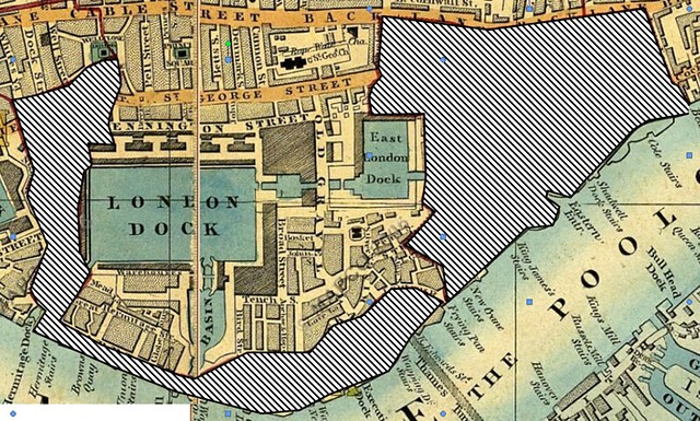
In this first map dating from 1850, I've shaded two parishes- St John Wapping to the West and St Paul Shadwell to the East (though I haven't bothered to draw the gap at the Pier Head by the river). The map I hope shows what an odd shaped parish St John's was.
Whilst the western boundary is determined by filling the gap between St Katharine and the London Dock, its run along the river is slightly odd, in that its boundary is actually the middle of Wapping High Street between the Pier Head (E) and the Hermitage Basin (W). In effect, the riverside wharves were in one parish/vestry and the buildings on the other side of the road are in another. Major roads are often used like this in deciding boundaries (read the Boundary Commission's thinking and proposals for LBTH), but what I find bizarre is the fact that its a single row of buildings bounded by the river on the otherside. I will try to find out what the earlier parish boundaries were to establish when this came to be.
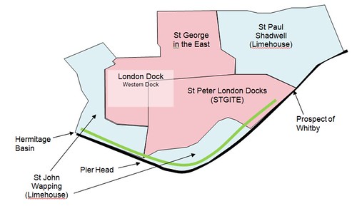
We know from my last post that things changed post 1855 and that the parish of St Peter's London Docks was created in the 1860s and these are reflected on my diagram below. The diagram is based on the 1877 parish map, and I've coloured the different parishes in Wapping according to which administrative district they belonged to: pink for St George in the East (not strictly a district) and blue for Limehouse.
In my most recent post, I discussed the boundary of the District of Limehouse and the parish/vestry of St George in the East as a result of the Metropolis Management Act 1855.
As noted in my last post, the act combined a number of parishes into 'districts' for the provision of certain services. Schedule B of the Act lists the individual parishes that were combined. Limehouse District was created from St Anne Limehouse, Saint John Wapping, St Paul Shadwell, and the hamlet of Ratcliffe.
Prior to the 1855 Act, St John Wapping was a vestry in its own right (the vestry hall would have been opposite the Town of Ramsgate) and was effectively split in two, as the Pier Head was all part of St George in the East, but the gap between the two parts was small - essentially the width of the lock/basin.
In this first map dating from 1850, I've shaded two parishes- St John Wapping to the West and St Paul Shadwell to the East (though I haven't bothered to draw the gap at the Pier Head by the river). The map I hope shows what an odd shaped parish St John's was.
Whilst the western boundary is determined by filling the gap between St Katharine and the London Dock, its run along the river is slightly odd, in that its boundary is actually the middle of Wapping High Street between the Pier Head (E) and the Hermitage Basin (W). In effect, the riverside wharves were in one parish/vestry and the buildings on the other side of the road are in another. Major roads are often used like this in deciding boundaries (read the Boundary Commission's thinking and proposals for LBTH), but what I find bizarre is the fact that its a single row of buildings bounded by the river on the otherside. I will try to find out what the earlier parish boundaries were to establish when this came to be.
Some level of common sense appears to have been applied, as you can see that the boundaries of the western part of St John Wapping has now been redrawn to include everything west of the Pier Head and south of the dock wall, so that the High Street (the green line) is no longer divided longitudinally. However, in the creation of the Limehouse district, part of St John Wapping is an exclave of Limehouse District, with St Peter London Docks not only preventing a contiguous district running from Limehouse, Ratcliffe and through Shadwell into Wapping, but also at the Pier Head.
I'm not sure what this meant in practice, but I imagine that given that the District was responsible for various public works such as maintenance of pavements and certain sewers (but not all - some were sufficiently important to be looked after by a central London body), this may not have been the most practical arrangement. But that's a post for another day.
So, returning to the title, no Wapping is not in North Africa, but part of it was geographically separate and surrounded by 'foreign' territory, and to my mind emphasises the changing psychogeography of the boundaries of Wapping!


Comments
Post a Comment
Please leave a comment to let me know if you think I've got it totally or partially wrong!