Know your boundaries - Limehouse
Was the Prospect of Whitby the boundary of Wapping and Limehouse?
What's in Wapping recently tweeted a photo of an information board in the beer garden of the Prospect of Whitby that states that:
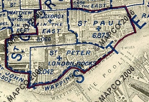
This parish map of 1877 (sourced from mapco here) below shows that a parish boundary did indeed exist (and still does) between St Peter London Docks and St Paul's Shadwell near the site of the Prospect (by the 'T' to the right of Shadwell). St Peter's London Dock dates from the 1860s when it became a separate parish to St George in the East which therefore would suggest the stone predates the 1860s).
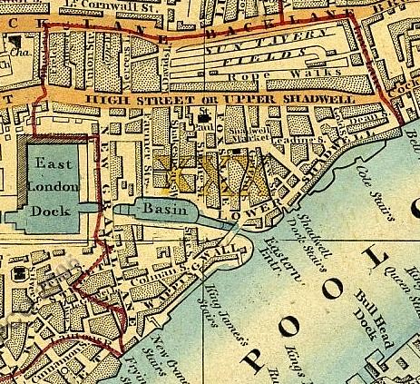
Looking a little further back, an 1850 map (below) shows the boundary between St George in the East and St Paul's Shadwell to be further west, indicating that the boundaries of the parishes must have been reconfigured at some point, but that crucially the boundary the stone marks did not exist.
What's in Wapping recently tweeted a photo of an information board in the beer garden of the Prospect of Whitby that states that:
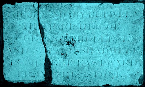
The stone here identifies this wall as the boundary between the districts of Wapping and Limehouse.There is a stone set into the wall which I depict below which I assume it refers to. (I have believe it or not added a coloured tint to make it easier to read on a screen)
The text on the stone reads:
The boundary between the Parish of St George Middlesex and St Paul's Shadwell is 9 feet Eastward from this stone
St George Middlesex was the previous name of St George-in-the-East, as it was within the county and parliamentaty constituency of Middlesex. On the face of it, there's no mention of anything to do with Limehouse, or Wapping for that matter.
A bit more reading educated me further about the exciting world of local government administration in the 19th century. In 1855, the Metropolis Act was enacted by Parliament that created districts from civil parishes or vestries. A 'district' of Limehouse was created from the parishes of St Anne Limehouse, Saint John Wapping, St Paul Shadwell, and the hamlet of Ratcliffe. This district was administered from Limehouse town hall. In the map above, the majority of the area shown is 'Shadwell', the red lines delineate the parishes. To the north east is Ratcliffe, to the West/NorthWest is St George in the East and to the South West is St John Wapping.
You can see a copy of a hi-res, high-detail map of St George in the East's boundaries here http://www.stgite.org.uk/library/1878vestrymap.jpg. St George in the East didn't become a district, presumably because it was a largeish parish compared to others locally, and the 'vestry' was administered from St George's town hall on Cable Street. However, I'll do some more digging and explain what this actually meant to Wapping in a later post (Wapping as we know now was administered by two different bodies with an exclave of one).
So, the stone does mark the boundary of Limehouse district as St Paul Shadwell was include in Limehouse, but I don't think there was ever a Wapping district, and indeed under these boundaries, Limehouse even recontinued further west along Wapping High Street and contains part of Wapping! Rather, the stone marks the boundaries in about 1855 of two adjacent parishes which were administered by separate bodies.


Comments
Post a Comment
Please leave a comment to let me know if you think I've got it totally or partially wrong!